Offered on campus, every Winter term, 4 credits in
Kelley Engineering 1001
Tues/Thurs 11:00-11:50 a.m., with lab sections on Tuesdays and Wednesdays
OR via distance ed. every Fall, Winter, and Spring, 4 credits
Main Web Site: http://dusk.geo.orst.edu/gis
Important Note to On-Campus OSU Students Who Wish to Take This
Course Via Distance Ed.: The distance ed. version of the course carries
a separate and EXTRA tuition fee, so, unfortunately, your GRA or GTA funding cannot be
applied to it. You may use scholarships or financial aid, but OSU Extended
Campus cannot (yet) bill against GRA/GTA funds. For more information, please
contact
Alfonso Bradoch of OSU Extended Campus.
PREQUISITE: NONE. HOWEVER, if you are
doing the Geographic Information Science undergraduate or graduate certificate, or hope to go on to a career in GIS, GEO 360 (Cartography, offered every fall) is
required. GEO 360 is only offered in the fall term, and if you have
not already completed this course or an equivalent, it IS possible to
take it during the following fall term, after completing GEO 465/565.
Students should also have some basic expertise with Windows computers with the
ability to perform basic tasks, such as moving, copying, saving, and deleting
files, making and changing directories, working with simple word processer and graphics programs, and navigating around the Internet.
|
|
This course covers fundamental concepts underlying computerized geographic
information systems (GISs) at an intermediate level (undergrads, see GEO 365
for an introduction to GIS). It combines an overview of the general principles of GIS with a theoretical
treatment of the nature and analytical use of spatial information (aka "spatial reasoning").
Although, the course has a laboratory component that exposes
students to the ArcGIS 9 and 10 software packages, it focuses more on the
science behind the software, the issues surrounding the use of the
software, and, once again, the fundamental nature and analytical use of spatial
information in various forms (i.e., geographic information science or GIScience). I want to emphasize again that it is the theory and concepts in the lectures of this
course that are at an intermediate level. For some students, many of the
laboratory exercises will be considerably easy for them. For other students,
the laboratory exercises will be very challenging. This course seeks to serve a very
broad enrollment of student backgrounds and experiences.
Good skills with the Internet and the World Wide Web will definitely
help you in this course. Notes, graphics, and multimedia resources will be placed
on the class web site for your benefit. I cover a lot of material in class
using PowerPoint presentation software and there will also be occasional
live demos and videos. In addition, you will be encouraged to explore my
"Web Site of the Week" on your
own time, which should help to solidify the concepts that you are learning
in lecture or lab. This may also serve as inspiration for the class term paper/project, or perhaps life in general!
|
By the end of this course it is expected that you will be able to:
- Synthesize and integrate concepts of GIS theory and methodology,
including data models, data structures, topology, and spatial analysis.
- Understand and articulate what geographic information science is and some of its
topics and challenges.
- Begin to articulate the role of space as a source for explanation and
understanding.
- Describe the functional basis of a GIS (i.e., how it works), including how it differs from other
computerized systems, and why.
- Consider and evaluate the benefits and shortcomings of using GIS for
a variety of natural resource applications.
- Outline the key data quality issues involved in using GIS and state
the importance of metadata.
- Demonstrate basic GIS software skills in the ArcView 9.x portion of ArcGIS, as well as basic scientific computing skills.
- Understand and articulate what GIS analysis is, understanding also that analysis is at the crux of GIS (not just holding data, organizing data, or making maps).
- Be able to perform a rudimentary spatial analysis in ArcView 9.x.
Additional and specific graduate level learning outcomes for GEO 565 students are to:
- More fully articulate the role of space as a source for explanation and understanding.
- Synthesize and integrate information, GIS analysis results, and
interpretations from the GIS/GIScience literature.
- Employ written communication and computer technology skills by way
of a term paper, analytical project report, or web-based annotated bibliography.
|
|
|
Textbooks
|
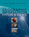 REQUIRED: Geographic Information Systems and
Science by Longley, Goodchild, Maguire, and Rhind, 3rd Edition
REQUIRED: Geographic Information Systems and
Science by Longley, Goodchild, Maguire, and Rhind, 3rd Edition
on reserve at Valley Library
"GIS technology is proliferating throughout the world in
myriad applications. While many technical books and writings
describe these uses, Geographic Information Systems and Science
explores many of the "real-world" applications of this rapidly
evolving field. In so doing, the book illuminates some of the
growing commonalities between the concerns of business,
government, and science; how issues of management, ethics,
risk, and technology intersect; and how GIS provides a
gateway to problem solving. Designed for readers who are
already familiar with GIS, this richly illustrated, full-color
book is aimed at intermediate-level undergraduate students,
postgraduate students, and busy professionals who need clear
and succinct information about this fast-developing technology."
Wiley or ESRI Press, 2010/2011, 560 pp., $79.20 (paperback),
ISBN: 978-0-470-72144-5.
Description from ESRI GISstore. Image used by permission.
| |
 OPTIONAL:
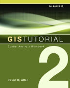
GIS Tutorial 2: Spatial Analysis Workbook,
by Allen, 2nd Edition for ArcGIS 10
OPTIONAL:
GIS Tutorial 2: Spatial Analysis Workbook,
by Allen, 2nd Edition for ArcGIS 10
Includes CD_ROM w/ the necessary ArcGIS 10 software and data
Updated for ArcGIS Desktop 10, GIS Tutorial 2: Spatial Analysis Workbook,
Second Edition offers hands-on exercises to help GIS users at the intermediate
level continue to build problem-solving and analysis skills. Inspired by the ESRI
Guide to GIS Analysis book series, GIS Tutorial 2 provides a system for GIS
users to develop proficiency in various spatial analysis methods, including
location analysis; change over time, location, and value comparisons; geographic
distribution; pattern analysis; and cluster identification. ESRI Press, 2010,
340 pp., $71.96 (paperbook), ISBN: 9781589482586. Description from the ESRI
Press Catalog. Image used by permission.
|
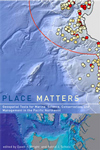 Place Matters: Geospatial Tools for Marine Science, Conservation, and Management in the Pacific Northwest
edited by D.J. Wright and A.J. Scholz, Foreword by Sylvia Earle
on reserve at Valley Library
Many students taking this course have expressed an interest in marine
and coastal applications of GIS. If you are in this category you may
enjoy this supplemental text, especially as we approach the lectures on
3-D and 4-D GIS. Place Matters explores how marine GIS is contributing
to the understanding, management, and conservation of the shores and ocean of
the Pacific Northwest, which is becoming a hotbed of marine GIS development
and applications as scientists expand the use of this cutting-edge technology
to a variety of ocean science, policy, and management issues. With its unique
focus on the use of GIS to solve marine conservation problems, Place
Matters offers an important new resource for all who study and work
to protect the world's oceans. Oregon State University Press, 2005, 272 pp.,
$29.95 (list), ISBN: 0-87071-057-5. |
|
LIBRARY INFO.
|
|
We have a wonderful library on campus and Andrea Wirth is our subject
specialist for geosciences/GIS (541-737-9903). See also "Ask a Librarian"
at osulibrary.orst.edu/reference.
You can access most of the library's databases at
osulibrary.oregonstate.edu/research.html
from outside of the library or off campus. Map resources are at
osulibrary.orst.edu/research/guides/maps/maproom.htm.
To obtain materials not in our collection, Interlibrary Loan forms
for books
and journal articles can be found at osulibrary.orst.edu/ill/.
There is a single GIS workstation in the Valley Library on campus. To my
knowledge, it is running ArcGIS 9.x, Erdas Imagine 8.5, and TIGER
CTSI. Contact Andrea for access and use policies, as well as
information about updates to software that has been installed on this machine.
|
|
GRADING
|
|
For undergrads enrolled in GEO 465, the midterm will be worth 30%, the
final 40%, and the labs 30%. For most grads enrolled in GEO 565, the midterm
will be worth 20%, the final 30%, the labs 20%, and an
annotated bibliography on the web or 20-page term-paper 30%.
Sample Weighted Percentage Calculations:
TOTAL=((M/100)*30)+((F/150)*40)+((L/400)*30)
where M = midterm score, F = final exam score, L = cumulative lab score
TOTAL=((M/100)*20)+((F/150)*30)+((L/400)*20)+((P/50)*30)
where M = midterm score, F = final exam score, L = cumulative lab score, P = term project
For the courageous graduate students in GEO 565 choosing the more difficult web mashup project option, the midterm will be worth 30%, the
labs 30%, and the project 40% (no final exam). Guidelines for the
projects and term paper can be found at dusk.geo.orst.edu/gis/projects.html.
End-of-the-Term Weighted Percentages for both GEO 465 and 565
- A = 95 -100
- A- = 90-94
- B+ = 85-89
- B = 80-84
- B- = 75-79
- C+ = 70-74
- C = 65-69
- C- = 60-64
- D+ = 55-59
(Letter grades are not assigned until the end of the term.)
|
|
Academic Dishonesty
|
|
Students are expected to be honest and ethical in their academic work.
Academic dishonesty is defined as an intentional act of deception in one of
the following areas:
- cheating - use or attempted use of unauthorized materials,
information or study aids
- fabrication - falsification or invention of any information
- assisting - helping another commit an act of academic dishonesty
- tampering - altering or interfering with evaluation instruments and
documents
- plagiarism - representing the words or ideas of another person as
one's own
For more information about academic integrity and the University's policies
and procedures in this area, please visit the Student Conduct
web site at:
oregonstate.edu/studentconduct/.
|
|
Students w/ Special Challenges
|
|
Students with documented disabilities who may need accommodations,
who have any emergency medical information the instructor should know
of, or who need special arrangements in the event of evacuation,
should make an appointment with the instructor as early as possible,
no later than the first week of the term. For further information
regarding accomodations for students with disabilities in this
class, please see the SSD web site at:
ssd.oregonstate.edu.
|
[ home |
lectures |
labs |
reminders |
surf ]
Last update: January 4, 2011
http://dusk.geo.orst.edu/gis/465desc.html
© 1998-2011 Dawn Wright
|